Table of Contents
- Make Decisions in Minutes, Entirely Offline, with Stand Assessment
- Map Instantly with Live Map Gen 3 Beta
- Automated Issue and Observation Creation in Procore and Autodesk BIM 360 Beta
- Keep Employees Safe with Facade Inspection Reports
- Improve Site Reality Data Access with View-Only Users
- Australian Datums & Australian Airspace
This April, we’re excited to launch products that drive field edge decisions, increase offline capabilities, and ensure data gets to those who need it most.
To kick off the agriculture growing season here in the Northern Hemisphere, we’re unveiling Stand Assessment, a revolutionary solution that performs automated, drone-based stand counts in a fraction of the time it takes to conduct counts manually. We’ve also completely rebuilt Live Map, allowing for 3x the mapping speed with unrivaled reliability. Both of these tools operate offline right at the field’s edge, so your team can operate at maximum efficiency to support operations and customers at critical times in the season.
For our customers in construction, property management, and energy, we’ve streamlined our inspection workflows. You can now connect tagged inspection issues to industry-leading construction management solutions Procore and Autodesk BIM 360 and close out issues with confidence in your system of record. If you’re conducting facade inspections using our Vertical Flight mode, you can now quickly generate customized Facade Inspection Reports.
For our Australian customers, we now support GDA2020 datum and Australian Airspace restrictions.
Given these new field analysis and site inspection tools, it’s more important than ever for your team, customers, and external parties to have access to data within DroneDeploy, and we’re releasing a new viewer bundle to help you do just that.
Make Decisions in Minutes, Entirely Offline, with Stand Assessment
We've heard countless stories from our sales and agronomists about how they used to scout 6 to 10 locations at 1/1000 of an acre, now they can sample 3 times more locations in the field at 100 times greater sample area all within 30 minutes.
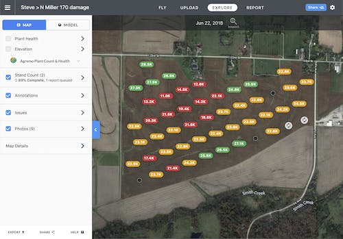
Today, our Stand Assessment solution is available to all annual agriculture customers. Stand Assessment will enable offline, real-time stand counts for corn and soy at the field’s edge. Anyone who’s ever conducted a stand assessment knows the process is time-consuming and laborious. Today’s best practice for corn is ground-based manual counting based on 1000th of an acre. Typically the variability and error rates for this process can be huge. Not only that, it requires hours of walking and mental arithmetic.
This new solution reduces 90% of the time it takes to conduct a traditional stand count. The deliverable report and interactive map are available immediately to text or email to your client.
We partnered with Corteva Agriscience, which has the largest commercial drone deployment in the US with over 1,200 global pilots, to bring this solution to life. They’ve developed a machine learning algorithm specifically for stand count, and it has been trained using more than 10,000 customer fields.

DroneDeploy Stand Count solution is simple, powerful, accurate, and completed entirely within DroneDeploy. First, define your field area, then customize your mission plan based on crop type (we support corn & soy at launch). Terrain Awareness is automatically enabled, ensuring a safe flight and consistent capture height. You’ll be able to cover 200 acres in as little as 15 minutes, with an interactive map and PDF report available just after the drone lands – entirely offline. AI identifies areas of good, moderate, and poor emergence with summarized population scores, gap counts, and annotated images, all automatically compiled in a report that you can share via text or email. If you want to investigate problem areas further, use the GPS marker on the DroneDeploy app to navigate to a field’s precise location.
All the analysis happens on the mobile device, so no need to upload images or use SD cards. For enterprise customers, all that data is accessible via our API and synced to the web portal for additional sharing capabilities.
Stand Assessment available to Precision Agriculture, Business Yearly, and Enterprise Plans
Map Instantly with Live Map Gen 3 Beta
Many of you have been using Live Map since its inception three years ago. This April, we’re releasing a beta for Live Map Gen 3. Gen 3 is 3x more powerful, thus allowing:
- Higher accuracy
- Faster results
- Greater reliability
What’s most exciting is it allows for faster flight speeds and less overlap – enabling you to map over 200 acres in one 15-minute flight on a single battery. Also, the map’s resolution is 18% higher, achieving a 1-inch mapping resolution with a single battery for a 100-acre field. And before the drone has even landed, you can start zooming in to analyze the data to find any areas of concern.
We’ve made improvements to remove image compression artifacts and stabilize the FPV feed. These enhancements guarantee you map each field with the highest levels of reliability and accuracy.
For our agriculture users, you can now scout fields faster than ever before, increase your team’s efficiency, and dedicate your time to addressing issues and supporting customers in the field.
For construction or energy users, you can assess site conditions in record time, plan navigation routes, verify asset locations, and with GPS navigation, walk directly to any areas of interest.
Live Map Gen 3 is an open beta available to all paid plans that will roll out in phases over the next few months.
Site Reality for Everyone on your Team: Automated Issue and Observation Creation in Procore and Autodesk BIM 360 Beta
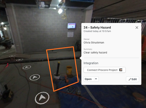
Before, customers could identify, tag, and assign issues in DroneDeploy within any view in the platform, including 2D map, 3D model, 360 Walkthrough, or facade. But, until today, that visual context created in DroneDeploy stayed in DroneDeploy.

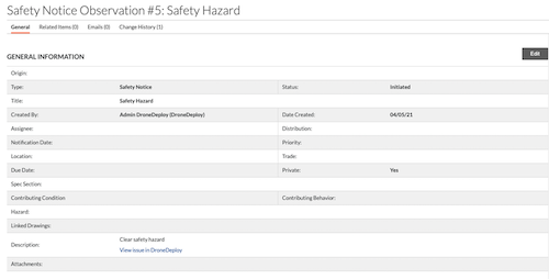
With this update to our current integrations to Procore and Autodesk BIM 360, customers will now be able to connect their inspection workflows. With complete synchronization of inspection issues, you can now automatically generate issues in Observations in Procore and Issues workflow in BIM 360 Document Management.

As a QA/QC Engineer who conducts and tracks most work in Procore Observations, issues documented on the job site using DroneDeploy must be automatically visible in Procore in order to correctly resolve that problem. Now, all of their colleagues and teammates have access to relevant site data to close out issues with confidence.
This new functionality is currently a closed beta, but will be available to Enterprise customers with the Procore or Autodesk BIM 360 Integrations. Please reach out to your account manager or CSM if interested in joining the beta.
Keep Employees Safe with Facade Inspection Reports
Many construction, energy, and property management companies invest thousands of dollars in swing stages or bucket lifts to conduct a facade inspection, and it can take days to complete. DroneDeploy removes the need for expensive equipment, reduces inspection time from days to hours, and removes employees from dangerous working conditions.

Easily navigate facades and annotate issues to identify hazards, confirm installs, check for imperfections, and assess OSHA compliance. Once documented, closeout issues with confidence using @mentions with teammates.
Facade flight, inspections workflow, and report are available only on Enterprise Plans
Improve Site Reality Data Access with View-Only Users
Open DroneDeploy up to your vendors, clients, and executives by giving them the ability to view progress on construction sites, understand crop emergence on early-season fields, or gain insight on asset inspections.
DroneDeploy is making enterprise organization management more flexible and intuitive to match your business needs. The new view-only subscriber has been made available alongside improvements to project and user management capabilities, increased admin visibility, and control over user data access. Ultimately, we want to ensure you have the flexibility to manage who has access to your data, whether they are employees, customers, or stakeholders.
View-Only subscribers are available to purchase on Enterprise Plans
Australian Datums & Australian Airspace
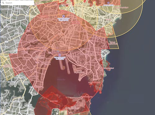
As we expand internationally, we need to update our platform compatibility with international datums and airspace restrictions. With this release, we now support Australian datums (GDA2020) in our GCP processing and export workflows, as well as Australian airspace restrictions.

When planning and conducting flights in DroneDeploy in Australia, you can now check for airspace authorization and view restrictions in your flight area.
Datum support available for Business and Enterprise, Airspace Authorization available to all plans.

